
We work across pristine and human modified temperate and tropical forest ecosystems to understand and generate new knowledge about their functionality, health and resilience. We contribute knowledge and tools for biodiversity positive and nature based solution analyses and aim at Increasing the positive impact of Earth Observation and ecological knowledge for evidence based policy making at local and global scale.
There is a tremendous need for understanding the state of our natural ecosystems. This need has been exacerbated due to the known decline in biodiversity and natural resources, in part due to Land use conversion, degradation of land and Ocean systems and climate change.
Although it is widely known that the terrestrial and ocean ecosystems are changing and tools have been developed to try to quantifying those changes we are still facing a lack of tools and indices that allow us to go beyond quantifying number of species, fragments, sizes and other spatial components towards finer structural, morphological and chemical aspects. Developing knowledge about the above highlighted aspects can improve our understanding about the processes of nature recovery and health of our ecosystems the process of nature recovery the process of nature recovery at small and large spatial extents.
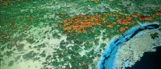
We use Remote Sensing and in general Earth Observation as the science that quantifies aspects of an ecosystem without being in direct contact with it. Up to now we have mostly used remote sensing products to quantify discrete aspects of local and global areas, such as counting the number of fragments in a landscape, its connectivity, distance between fragments and sizes, and for characterizing land use and quantifying its changes. Besides generating those common landscape metrics we are also using satellite and UAV (unmanned aerial vehicles) remote sensing to bring a novel understanding on the structure, morphology and chemistry of land ecosystems across space and time. With our new approaches we are gaining a new understanding on ecosystem health, their paths to recovery and their resilience to global environmental change.
We use multi/hyperspectral and vegetation structure from LIDAR (light detection and ranging) sensors mounted in drones which imagine the landscapes at extremely high spatial and spectral resolution of a few centimetres. We also make use of state of the art satellite earth observation to extrapolate our local findings to the regional and global extents. We are currently specially working with the Copernicus constellation of Sentinel satellites from the European Space Agency (ESA) and the Landsat satellites and GEDI LiDAR (Global Ecosystem Dynamic Investigation) missions from NASA.
Related Projects

Understanding nature recovery paths and ecosystem functioning through forests health assessments
Quantifying the health of forests ecosystems by means of earth observation can aid in understanding nature recovery paths and ecosystem functioning
Mapping the resilience of tropical forests and savannas to global environmental change
Climate change effect on tropical forests

Social ecological mapping for nature recovery
Developing social ecological maps for land use planning, investment and inclusive decision-making.
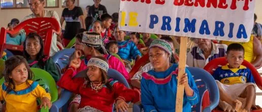
Research at the interface of indigenous and Western science
Empirically applying an intercultural interdisciplinary mapping methodology “Non Oñamboan Joi” for assessing nature recovery potential in the Amazon.

Remote sensing approaches to characterise pollinator diversity and plant-pollinator interactions in nature recovery landscapes of Eastern Ghana
Evaluating the effects of nature recovery on pollinators their interactions with plants.
Bridging Field Data and Vegetation Models: Forest Carbon Cycling Across Scales
Vegetation models have been used by many organisations (including the IPCC) to predict climate change on a global scale, but are these models getting the current ecosystem right?
Related Outputs
Tropical forests in the Americas are changing too slowly to track climate change
Species are expected to shift their ranges as the climate changes, but shifts may not occur fast enough, especially for immobile species such as plants. Two papers in this issue assess the degree to which plant species are tracking climate change in the American tropics, where data availability has constrained inference.
Canopy functional trait variation across Earth’s tropical forests
Tropical forest canopies are the biosphere’s most concentrated atmospheric interface for carbon, water and energy. However, in most Earth System Models, the diverse and heterogeneous tropical forest biome is represented as a largely uniform ecosystem with either a singular or a small number of fixed canopy ecophysiological properties. This situation arises, in part, from a […]
The political ecology of cocoa agroforestry and implications for equitable land use in rural Ghana.
The relevance of cocoa agroforestry is widely discussed in debates on sustainability transition in cocoa, especially in the context of ending hunger and poverty among cocoa farmers. Whereas this has led to multiple cocoa agroforestry investments by NGOs, governments, and cocoa and chocolate companies in West and Central Africa, a notable gap exists in the […]
Contrasting carbon cycle along tropical forest aridity gradients in West Africa and Amazonia.
Tropical forests cover large areas of equatorial Africa and play a substantial role in the global carbon cycle. However, there has been a lack of biometric measurements to understand the forests’ gross and net primary productivity (GPP, NPP) and their allocation. Here we present a detailed field assessment of the carbon budget of multiple forest […]
More than 17,000 tree species are at risk from rapid global change.
Trees are pivotal to global biodiversity and nature’s contributions to people, yet accelerating global changes threaten global tree diversity, making accurate species extinction risk assessments necessary. To identify species that require expert-based re-evaluation, we assess exposure to change in six anthropogenic threats over the last two decades for 32,090 tree species. We estimated that over […]
Valuing the functionality of tropical ecosystems beyond carbon
Land-based carbon sequestration projects, such as tree planting, are a prominent strategy to offset carbon emissions. However, we risk reducing natural ecosystems to one metric – carbon. Emphasis on restoring ecosystems to balance ecosystem services, biodiversity conservation, and carbon sequestration is a more appropriate strategy to protect their functioning.